
Plotting geo coordinates on map
In case you want to plot geo coordinates on a map:
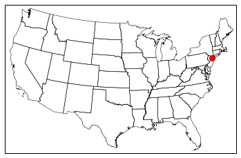
In this example, we want to plot geo coordinates on a map of US states.
In order to do that we first need to install some dependencies. Most important are the following:
pip install matplotlib
pip install basemap --allow-external basemap --allow-unverified basemap
The solution is based on this question: Stackoverflow question
Keep in mind to have the following files in your script directory (Can be found here):
- st99_d00.shx
- st99_d00.shp
- st99_d00.dbf
import matplotlib.pyplot as plt
from matplotlib.patches import Polygon
from mpl_toolkits.basemap import Basemap

# create the map
map = Basemap(
	llcrnrlon = -119, llcrnrlat = 22, urcrnrlon = -64,
	urcrnrlat = 49, projection = 'lcc', lat_1 = 33,
	lat_2 = 45, lon_0 = -95)

# load the shape file with "states"
map.readshapefile('st99_d00', name='states', drawbounds=True)

# set a geo coordinate (for example, new york)
lat = 40.7127
lon = -74.0059
x,y = map(lat, lon)

# place it on the map
map.plot(x, y, 'ro', markersize=4)

plt.show()
The result should like:
Written on July 19, 2015